Roof-level solar detection for smarter sales.

Identify which buildings already have rooftop solar – and where the next best customers are. Use satellite-derived maps to focus your sales efforts on the highest-potential streets and regions.

Regions coveredPrimarily EU & USA
Update frequency< 7 days
Data sourceESA
Roof classification
Flying to next house...

At a glance

Roof Solar Detection turns satellite imagery into a clean rooftop-level dataset, telling you exactly which buildings have solar installed – and which ones are still untapped opportunities.

🏠
Rooftop-level visibility
Detect which buildings already have solar installed and which rooftops are still untouched.
🎯
Sales-ready targeting
Build lead lists of high-potential roofs by postcode, city, or custom territory – ready for your sales team.
📈
Market penetration tracking
Measure solar adoption by region to see where competitors grow fastest and where untapped demand remains.

What you can do with this data

Turn rooftop-level solar information into qualified leads, smarter sales territories, and clear market intelligence.

📋

Lead lists for installers

Export buildings without PV systems in your target region and route sales reps only to high-potential streets.

🗺️

Territory & quota planning

Prioritise postcodes and cities with the highest share of non-solar roofs and set realistic targets per region.

🔍

Lost opportunity analysis

See where competitors already installed systems – and quantify how many leads slipped to other providers.

🏛️

Market share & policy tracking

Track solar penetration over time at city, region, or country level to monitor rollout speed and coverage.

Data to boost your sales pipeline

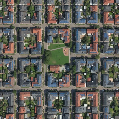
Our models analyse high-resolution satellite imagery to classify every rooftop as “solar installed” or “no solar yet”, enriched with location and basic building attributes. The result is a clean, sales-ready dataset that plugs directly into your CRM, analytics stack, or territory planning tools.

Enterprise Solar Detection

Access building-level solar installation data for entire regions. Our enterprise datasets include installation status, potential scores, and exact location attributes.

🏠
Building-level
🎯
Targeting insights
📍
Exact address

Currently only available for enterprise.

How on-demand products work

Request custom analysis for your region and time period, then download the results with a single click.

1

Select Product & Parameters

Choose your data product, geographic scope, and time period.

2

Satellite & ML Analysis

Our system processes satellite imagery and runs machine-learning models.

3

Email Notification

Receive an email as soon as your data product is ready for download.

4

Download & Reuse

Your product is added to the shared catalogue and can be reused across your team.

Once created, on-demand products can be reused across your organisation.

Sample data preview

Delivered as a clean, tabular building-level dataset – ready for lead generation, market analysis, and dashboards.

Roof Solar Detection sample preview
Building ID City Maps Link Has solar Timestamp
BLD-102345Paris, FranceView on MapsNo2025-12-28
BLD-209876Berlin, GermanyView on MapsYes2025-12-28
BLD-304512Amsterdam, NetherlandsView on MapsNo2025-12-28
BLD-498877New York, USAView on MapsYes2025-12-28
BLD-587321San Francisco, USAView on MapsNo2025-12-28

* In the downloaded dataset, the Maps Link will direct to the exact building location on Google Maps.

Ready to find your next best customers?

Create your free account, explore sample regions, and start building solar lead lists today. Upgrade to full coverage once you see the value.